
Forestland Value Comes in Many Forms
Logs, location, species, size, soils, accessibility... and the economy.
Discover the Power Behind Your Property
The Forest Resource Analysis System Software (FRASS) transforms ordinary parcel data into a complete financial and biological profile of your forestland.
Each property record becomes a secure analytical workspace—connecting mapped acres, timber stands, and market data into one unified framework.
FRASS is your operational valuation platform.
Delivered as a cloud-based Software-as-a-Service (SaaS), it requires no special hardware or local installation.
All computation, data security, and model processing occur within the FRASS environment, giving users access to enterprise-grade analytics through a simple web browser.
Each subscription account is fully private and may include multiple Authorized Users, allowing managers, appraisers, and consultants to collaborate on the same property portfolio.
Your input data—forest inventory, GIS layers, and custom assumptions—remain your intellectual property.
Our licensed analytical modules—including the Flex Taper model, Delivered Log Market Portfolio, and Real Price Appreciation (RPA) forecasts—work behind the scenes to quantify value, cost, and opportunity for every timber stand.
From acreage to asset, FRASS links field measurements, spatial context, and market performance to reveal the real economic potential of your forestland.


Forest Resources, Guided by Intelligence
Every forest is unique, yet every property shares a common goal: sustained value through informed management.
The Forest Resource Analysis System Software (FRASS) empowers landowners, investors, and analysts to reveal the full financial and ecological potential of their forestlands.
FRASS brings together biometric growth data, spatial context, and market intelligence to deliver decision-ready insights.
Through its integrated modules, users can identify optimal harvest rotations, evaluate management alternatives, and forecast long-term returns—all within a defensible analytical framework.
Maps generated through the FRASS GIS interface visually link the biological, spatial, and financial dimensions of each parcel, exposing both constraints and opportunities that conventional analyses overlook.
From Maps to Markets
Static maps show where resources exist. FRASS goes further—turning those layers into operational intelligence.
A built-in map viewer connects high-resolution aerial and infrared imagery to detect vegetative vigor, soil moisture, and riparian dynamics in real time.
Users can zoom into stands, visualize site productivity, and assess management impacts spatially before committing resources.
At the same time, FRASS’s economic engine projects delivered-log market prices by sort and grade, forecasting financial outcomes over multiple rotations.
The system combines biological growth forecasts with inflation-adjusted price trends from the Real Price Appreciation (RPA) model to evaluate the timing and scale of each potential harvest.
Every rotation contributes to a comprehensive property-level valuation—measured in Net Present Value (NPV)—and grounded in both current and future market realities.
From Concept to Capability
The integrated FRASS system bridges the worlds of forest science and financial analytics.
While many specialists have long understood these concepts, FRASS is the first platform to make them universally accessible—uniting biometric precision, spatial intelligence, and economic forecasting within a single, intuitive environment.
Subscribers can test unlimited what-if scenarios—adjusting market trends, management strategies, or site conditions—to reveal outcomes in minutes, not weeks.
This speed and reliability come from the same technologies used by advanced financial systems: secure SQL Server databases, econometric modeling, and optimized ASP.NET processing pipelines, all refined through years of field-tested experience and common sense.
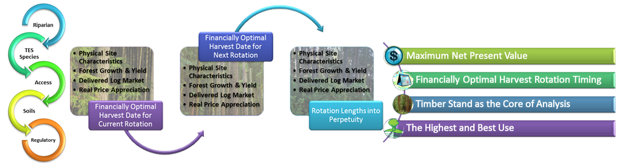
The FRASS Property Intelligence Framework
Each forest property analyzed within the FRASS Analytics platform passes through a structured sequence of evaluation—transforming raw physical data into actionable financial insight. This framework connects biological, spatial, and economic dimensions of your land into one coherent value system.
- Geospatial Analysis — Defines acres, roads, slopes, and riparian buffers to determine operable land and cost relationships.
- Biometrics — Uses field and modeled tree data to describe how each timber stand grows and changes through time.
- FVS Integration — Imports standardized growth data directly into the FRASS server for stand-level reconciliation.
- Flex Taper Model (Patent Pending) — Transforms tree form and taper into log-level value using δ-based geometry.
Together, these modules form the foundation of Properties in FRASS—the integrated view where biological growth meets financial optimization.
FRASS YouTube Channel
While you watch these videos, click the CC (Closed Captioning) button to read along with the narration.

FRASS YouTube Channel
Watch FRASS theme videos on our playlist, subscribe to be alerted when new videos are posted!