Make FRASS a part of your Appraisal
Licensed Appraisers: FRASS accelerates your precision.
FRASS Appraisal reports include maps of the subject property and photographs in its current condition. We explain all economic assumptions made about properties (inflation, interest rate, discount rate, Real Price Appreciation of the timber species by sort and grade), forest biometric projections of Growth & Yield to conjure the future values of the subject property which are discounted to current day terms (Income Capitalization Approach). As a result, we bring intense analysis to FRASS Appraisals using data normally collected while managing forestlands to discover value of the Highest and Best Use.
Property Management Needs
FRASS Platform client account data were initially designed to host forestlands owned by a company, tribe, organization, or agency. The size of properties includes collections of parcels from 1,000 acres (400 hectares) to 25 million acres (10 million hectares). We manage those data with access provided to authorized users, with different levels of approved data manipulation. These might include access by the organization’s Forest Manager with full account access, a GIS analyst with a different authorization for changing data. In a similar way, access for the Forest Biometrician gives specific data manipulation authority when needed.
Within the FRASS Platform, all users can share data confidentially and securely. FRASS Appraisal reports are generated alongside actionable data for each resource manager. Every manager and analyst involved with the property uses the same information to discover their goals.
We host Consulting Foresters with their client’s data managed as separate and unique properties. Individual clients can view information about their specific lands. The Consulting Forester group receives access to all of their client’s data files, can implement differential owner characteristics to the property data, and get unique analysis results for each.
Appraisers can use the same approach as Consulting Foresters use to create a confidential FRASS Platform account, allowing access to specific customer property information. This facilitates Licensed Appraisers to enter specific property data for each appraisal being made. The FRASS Appraisal report feature accelerates how professional analysts find results with confidence and accuracy.
The options abound when data are integrated into the FRASS Appraisal Platform.
Unique Appraiser Needs
FRASS Approach benefits from collecting property data useful for current decision making and long-term planning. Forestland data management is assembled from a broad collection of input date, including Geographic Information Systems (GIS) and Forest Biometrics all blended through the Forest Econometrics approach. This information includes data about adjacent properties, complete attribute mapping, road use, and strategic tree species selection for reforestation.
Ultimately, the Forestland Appraiser, applying the Income Capitalization Approach to valuation, can use this platform with certain GIS data:
- Aerial Photography,
- Road Networks,
- Stream Networks,
- Riparian Zones,
- Soil Types (where available),
- Timber Stand Boundaries.
These GIS themes express fundamental value components of each property. Beyond this, the Licensed Appraiser needs to acquire forest inventory data. Those data are filtered through a forest biometrics platform, as described on this site, to project Growth & Yield in terms of species sort and grade volume. Those data can be joined with the market data maintained by D&D Larix, LLC, to project future values, which are discounted to current day terms as needed by the analyst.
Ultimately, these are dissected into merchandised sort and grade log volumes to be matched with market projections. It results in actionable results of value projections through time.
This is where those data are joined and made into meaningful value projections.
Forest Inventory Data
Forest Inventory data is a fundamental part of commercial and agency forest management activities. Many forestland owners collect and maintain these data. When an Appraiser has access to these data, they are used for making the appraisal report. If they are not available, Licensed Appraisers can work with a local Consulting Forester to collect them. Those data are processed to reveal current and expected future timber volume on the property.
Forestland managers will have several layers of data they include in their forest management data collection events. The Licensed Appraiser may not investigate forestland properties to the same extent when preparing an Appraisal. Generally, a statistically reliable forest sample will include:
- No fewer than 7 plots per timber stand, and
- No less than 1 plot per 15 acres (6 hectares)
These rules-of-thumb are good when timber stands have been well defined. Trees within each timber stand are uniform in age, density, and merchantability. Oftentimes, it is not recommended to include river riparian zones in the same timber stand as a commercial forest sites. Harvest determinations and value will be different.
Finally, do not ‘over-stratify’ forest properties. Do not slice the property into timber stands less than about 10 acres (4 hectares). This could easily be relaxed to timber stands not smaller than 20 acres (8 hectares). This all depends on the characteristics of the property being appraised. The data collected is converted with other data to make the estimates needed when making income generation estimates.
Licensed Appraisers do not have to be professional foresters, but they might be. Decide how you are going to assemble the data needed to make accurate value predictions about the property, filter those data through FRASS and discover your results.
Some Example Reports
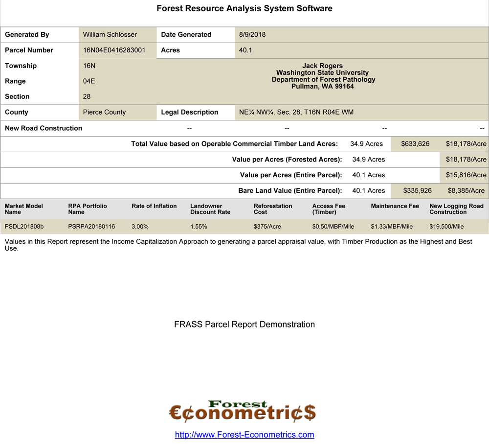
↑ The image shown above ↑ is linked to a parcel report generated from the FRASS Demonstration site. The PDF is 45 pages and 7.12 MB in size, so let it download to your local machine. It includes components a Licensed Appraiser would put into an Appraisal Report using the Income Capitalization Approach of forestland value. On this 40 acre parcel, there are 7 discrete timber stands. Maps, photographs, and value from each timber stand are part of the analysis process.
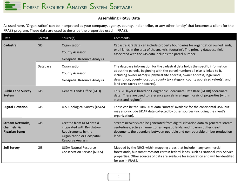
↑ The image shown above ↑ summarizes what data are used to generate the results found through the FRASS Process. Some of these data are acquired from public sources, some from our client’s databases, and some we create for use in FRASS. Take a look, you might be a lot closer to launching your FRASS Platform then you thought.
MASS Appraisals
Forestland-based MASS Appraisal systems use mathematical expressions of how supply and demand factors interact in markets. These are applied to statistical standards to properties within the collection of lands. Properties are combined into a market area where supply and demand consistently influence the value of timber commodities.
MASS Appraisals are appropriate for landowners with a few, or several parcels in the same market region. These fit nicely where landowners have their ownership consolidated into a contiguous mass, or scattered around the region. The uniting factor is the landowner with a common motif of managing forestlands to optimize financial profitability. This is where forestland Appraisers can apply the Highest & Best Use (HBU) principles. Financial optimization of the forestland property is found in FRASS.
This is where answers are discovered, through our rigorous econometric process. Miraculously, answers can be found within the FRASS Profile within minutes by authorized users. The data are maintained, combined with current econometric measurements, and made accessible to users 24/7.
Streamline Your Appraisal, Boost your Precision
Licensed Appraisers may be thinking that FRASS is doing what they have always done when preparing appraisals. You might be thinking that the other Appraisal Approaches discussed here are ‘just fine’ for forestland appraisals and all this additional forestry work is lost time. You might be right. FRASS is a new technology and people are not always ready to “take on the new game in town”. Others will recognize how this approach is a game changer, and be ready to use this technology.
If you are prepared to look into this MASS Appraisal technique, expressed through FRASS, we want to talk with you. While it looks like a lot of data are needed to launch into a FRASS Platform account, you may be surprised! We can assist Forest Consultants, Licensed Appraisers, large or small forestland owners to accumulate GIS and Biometric data needed to initiate property records.
It can take a week, month, or year to move from a FRASS Profile start to launch, depending on the land area considered, region, and the amount of data already assembled. We will work with you and your organization to make these findings actionable for you.
Contact us, now: FRASS@Forest-Econometrics.com.